What’s involved in scoping a site for a floating offshore wind project and why? And what issues must the industry consider going forward? We delve deeper!
Nicholas Jones is a Technical Director specialising in site surveys. We asked him what site investigation for floating wind projects will entail and what challenges the industry could encounter. With oil and gas developers increasingly involved in floating offshore wind due to the deeper water nature of the environments, Nick, who has experience in both, talks about reasons for some of their similarities and differences in approach between the industries. Here’s what we learned from our conversation.
Surveys protect against project risk
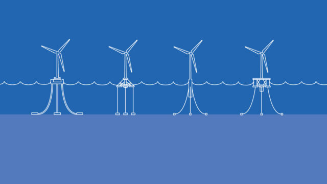
Floating offshore wind has some big differences from fixed, starting with the switch from shallow to deep-water environments. There’s no foundation to sink into the seabed, but more points of contact with the seafloor and increased distance between wind farm and shoreline.
So where do geoscience surveys come in? Investigations like these are all about advising clients on how they can minimise risk. Geoscientists can make recommendations on what ground conditions to expect in the array and cable corridor, and how to assess the risk to cable and anchor points as well as informing other aspects of design and engineering. They investigate what geological conditions or possible hazards are present, ensuring the entire cable route and arrays are sufficiently sampled to reduce unknowns.
The analysis stage is crucial and extensive
The duration of geophysical surveys for offshore wind farms is quite variable depending on their size and the weather conditions encountered during operations, but these generally take around one to two months. This is followed by geotechnical surveys of around two to three months. The acquisition of the data itself is quite a swift process; it’s the analysis that can take time. The “measure twice, cut once” frame of mind is essential for design. It enables engineers to correctly identify what kinds of structures and fastenings will be suitable to keep turbines in place and performing efficiently in the harsh deep-water environment.
Site survey data: how much is too much?
There’s a risk that floating wind’s first wave of commercial projects will be ‘over-spec’d’ (surveyed and designed according to overly strict parameters) and therefore over-engineered in comparison to shallow-water wind farms. Projects will want to reduce risk and satisfy evolving regulations, but the upshot is increased project costs.
There’s also the question of repeat visits to reacquire data. Some projects do this again and again—even when there’s a “best in class” dataset already available. Others acquire very dense geophysical data, but the more you gather, the more you have to analyse. Instead, the aim should be to acquire data in the most efficient way possible. The right consultant should optimise planning and management of this—it should be cost-effective, while getting to the answers and evidence you need.
How it compares to other energy industries
How floating offshore wind projects acquire data will make a big difference. There’s a lot of variation in approach, and even within a particular region, there can be a lack of continuity.
Oil and gas works on the licence block or multi-client (MC) model. For the MC model, survey companies acquire data for vast areas, selling to clients who express an interest if the data is likely to be relevant to them. The licence block can also be sold on, allowing the developer to recoup some of their costs. Floating offshore wind, meanwhile, is currently entirely proprietary or government-backed, while the MC model hasn’t been applied in fixed offshore wind (to date) due to differences in leasing processes and how developers operate. However, it is being considered, for example for wind resource data. How floating offshore wind’s processes evolve—and the direction data gathering takes—will be telling.
Government involvement and support for floating wind site surveys
In a bid to improve the process, some governments are taking full or partial control of data acquisition. The UK government is doing this in the Celtic Sea and will interpret the data before releasing the initial ground model (created to help identify suitable development areas and cable corridors). The Dutch government is covering the costs of top-class geophysical and geotechnical campaigns—at many millions of Euros—and will also release the data to developers. This approach removes some of the expense but also some of the planning, management, wait times and other hurdles prior to development, essentially de-risking the project prior to the leasing process.
Good things come in small packages
When it comes to design, it’s also not just a question of where the anchor goes. Instead, highly detailed seabed and subsea surveys will be needed to truly understand project requirements. This limits the type of approach where a survey company acquires large swathes of data in one go. Floating offshore wind will need to think of surveying in terms of much smaller parcels—which will yield more focussed and relevant information.
Changing the proposed location of a wind farm is challenging, so micrositing (investigating and defining a specific area for development) must be effective. This is another difference from oil and gas, where directional drilling—drilling non-vertically—means certain geohazards or features can be avoided. The exact site proposed for an oil and gas project isn’t “set in stone” in the same way.
Coming from oil and gas, however, developers will have to be ready to take “a different attitude to data”. They will need more detail, and in some cases, they will also be required to share that data to help the industry develop.
The challenge of how to “spec” or scope studies correctly is important, but this is where our experience at Tetra Tech makes us well suited to support our clients.
Drawing on a range of energy industry experience
Nick sees many new entrants into technical roles looking to specialise in renewables, but points out the value of geoscience skills learnt elsewhere. These could also be set to decline as senior oil and gas consultants retire. For example, he points to the link between geophysicists or geologists and engineers:
Engineers put the steel in the earth, but the geoscientists tell them what’s there to begin with. You have to be able to communicate well – almost in a different language as the engineering side is so different from imaging or subsurface imaging. That type of communication is an integral part of working in the oil and gas sector.
Tetra Tech’s skills are broad and multidisciplinary. We carry out site investigation, data QC and analysis, but also environmental assessment, metocean studies, UXO, and more. We set the tone for quality and experience, so we can walk the client right the way through the asset development.
Tetra Tech explores key challenges for developers. Our offshore wind consultancy team provides solutions and insights for developing in the Celtic Sea.
Connect with us. Reach out to our offshore energy experts in the UK and Europe.
About the author
Nicholas Jones
Nicholas Jones is technical director of our geoscience consulting team.
He has more than 10 years’ industry experience in geophysical site surveys, geoscience site characterisation projects (including geological desk studies and ground modelling) and related project management.
Nick uses his deep operational and technical experience to support clients in the renewables and oil and gas sectors, managing and leading projects across northern Europe, including in the North Sea, Irish Sea, Celtic Sea, Kattegat, and Baltic Sea.
Prior to joining Tetra Tech, Nick gained six years’ experience as an interpretive geophysicist on wind farm projects, cable routes, and drilling hazard projects.