Tetra Tech’s Renee Walmsley, vice president and head of the geomatics team, shares how our experts use advanced visual mapping tools to manage vegetation for power delivery projects.
Tucked between the hard realities of power delivery and the soft, relentless growth of vegetation, lies a technical art: identifying where trees and brush threaten overhead conductors before they cause outages. Tetra Tech approaches this challenge with a blend of careful planning, advanced remote sensing, and pragmatic delivery, turning terabytes of raw data into clear, prioritized action for utilities. The result is not just better maps, but faster decisions, safer crews, and fewer interruptions for our clients.
Managing vegetation near power lines is one of the most critical and expensive operational challenges for electric utilities. The immense geographic scale of overhead networks and climate-driven extreme weather patterns elevate the risk of line strikes causing catastrophic wildfires or major outages. Utilities also face challenges such as limited inspection budgets, difficult terrain, fragmented data sets, aging infrastructure, regulatory pressure, and the need to respond quickly to rapidly changing vegetation growth.
Furthermore, outdated tracking methods and fragmented data sets make it extremely difficult for utilities to deploy targeted and predictive maintenance strategies. Tetra Tech’s approach helps to reduce inspection costs, improve compliance, support risk-based planning, and use maintenance resources more efficiently.
Optimizing Technology Platforms
Every effective vegetation management program starts with a comprehensive strategy that prioritizes grid reliability and outage prevention. Our geomatics team works side by side with utility partners to shape acquisition plans around corridor dimensions, clearance risks, seasonal leaf cycles, and airspace limitations. This is especially valuable for municipal utilities managing service territories up to 900 square miles with limited field staff and short maintenance windows.
Our experts choose the best mix of cost-effective platforms, including drones, manned fixed-wing aircraft, helicopters, and targeted ground surveys to maximize return on investment and the spatial extent of the corridors. We pair these platforms with survey-grade global navigation satellite systems for precise positioning, LiDAR for three-dimensional structure, high-resolution imagery for visual checks, and multispectral sensors for plant-health insights.
This diverse array of airborne sensors detects early warning signs of stress while keeping field crews out of impassable terrain, directly enhancing worker and public safety. Remote sensing also enables utilities to inspect long stretches of line faster than traditional patrols, expand coverage into remote or hazardous areas, and identify issues before they become emergencies. Additionally, the team builds in rigorous ground controls and spot checks so the final deliverables perfectly match what crews see in the field.
Accelerating Data Processing
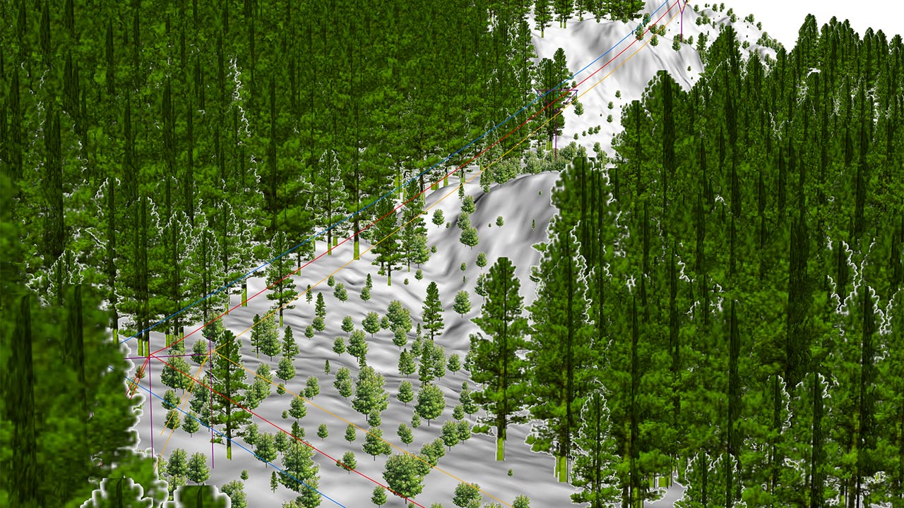
Once gathered, our geomatics experts process the raw data to produce practical, actionable outputs that can drive significant reductions in operational costs and time. We clean and classify raw LiDAR points into accurate surface models, while high-resolution imagery is mapped into visual, georeferenced formats.
We convert multispectral data into specialized vegetation indices to flag dead or fast-growing plants, which enables proactive removal before they create emergency hazards. We also use our Tetra Tech Delta tools, including customized AI modeling software and machine learning, to measure conductor-to-vegetation clearances, pinpoint potential contact zones, and score sections of the right-of-way by their wildfire risk.
All data then receives intensive quality assurance checks to ensure the results are reliable, defensible for regulatory compliance, and ready to prevent line-to-vegetation ignitions. These digital workflows also help utilities standardize assessments across crews and regions, reduce subjective judgment, and create a repeatable record for audits, planning, and reporting.
Transforming Data Into Actionable Information
To ensure instant integration and frictionless adoption, the geomatics team packages the processed work so crews and planners can take immediate action. Utilities receive georeferenced point clouds, orthomosaics, shapefiles, clearance reports, and interactive map services that plug directly into existing GIS and asset management systems.
This immediate access to field-ready maps eliminates the need for slow, traditional patrols. Planners use the integrated dashboards to schedule seasonal trims, give field crews precise cut lists, and verify post-trim compliance. This ensures that accurate data is instantly accessible within the specific software tools that operational teams are already familiar with.
Remote sensing provides additional benefits by supporting faster storm response, prioritizing urgent maintenance work, improving vegetation risk forecasting, and helping utilities allocate crews and capital more strategically. It also gives utilities a clearer long-term view of vegetation growth trends, making it easier to shift from reactive trimming to predictive, risk-based maintenance.
For utilities dealing with aging infrastructure and rising reliability demands, pairing remote sensing with practical, interoperable delivery is a scalable approach to keep lines clear and service reliable. In a setting where vegetation growth, weather, and system conditions are constantly changing, this approach gives utilities the visibility they need to act earlier, reduce outages, and improve overall grid resilience.
Tetra Tech provides integrated mapping solutions using state-of-the-art mapping software, airborne and mobile sensors and camera systems, and a robust information technology infrastructure.
About the author
Renee Walmsley
Renee Walmsley is Tetra Tech’s remote sensing director and leads the Tetra Tech Geomatic Technologies Group.
Renee has more than 25 years of experience in the environmental resource management and consulting industries. She is a certified geographic information systems professional (GISP), Federal Aviation Administration (FAA) unmanned aircraft system (UAS) remote pilot, and Project Management Professional (PMP) and has worked as a program manager for more than 15 years.
Her expertise includes using GIS and remote sensing technologies as a part of various job requirements at locations throughout the U.S. and on international projects. She has managed many aspects of remote sensing, photogrammetry and GIS mobile mapping, including data development and analysis, image classification, and new sensor technologies.
Renee also serves on the Management Association for Private Photogrammetric Surveyors (MAPPS) Board of Directors, the U.S. association for private sector geospatial firms.