Mitch Liddell, ground penetrating radar (GPR) platform lead, supports the application of advanced subsurface mapping technologies for infrastructure and utility investigations.
He specializes in deploying 3D GPR systems that deliver high-resolution subsurface data, helping clients reduce excavation, minimize traffic disruption, and avoid project delays. Mitch works with multidisciplinary teams to deploy non-destructive 3D GPR systems that provide critical insights for pavement assessments, bridge deck evaluations, and utility detection.
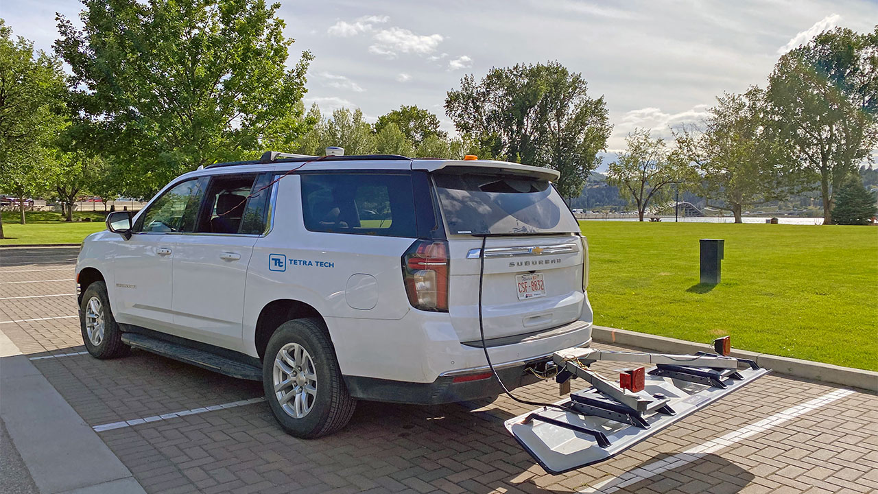
At Tetra Tech, Mitch leads the deployment of a 3D GPR system that operates across broadband frequencies and captures 25 data channels in a single approximately 2-meter-wide swath. This system enables near real-time analysis, centimeter-level accuracy using real-time kinematic (RTK) GPS, and clear visualizations through Kontur Examiner software. He holds a Doctor of Philosophy in Geophysics and Seismology from Imperial College London and a Master of Science in Geophysics from the University of Alberta.

What trends are you seeing in subsurface mapping, and how is the field evolving?
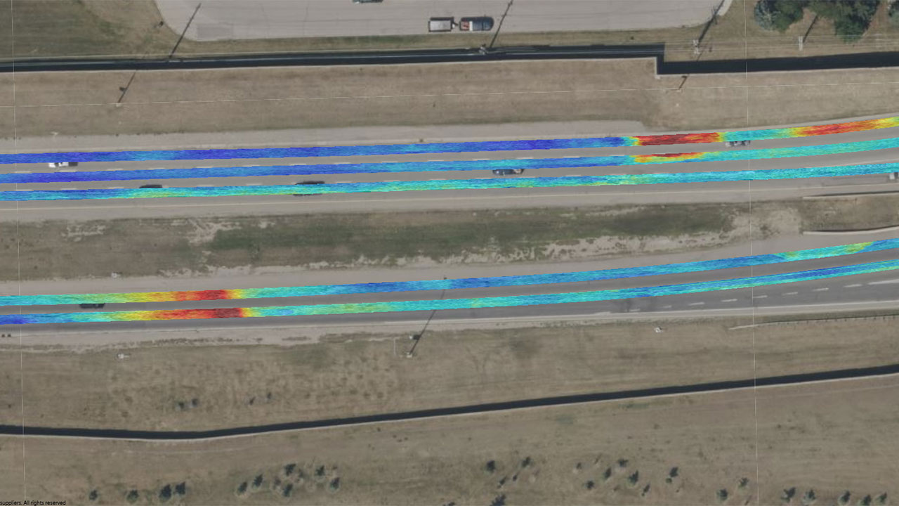
As cities become more complex, there is a growing need for reliable, high-resolution, non-invasive mapping technologies that reduce risks, minimize delays, and save money in infrastructure and utility projects. Tetra Tech has invested in world-class 3D GPR to address this need. The system allows us to conduct traffic-speed surveys while collecting 25 times more data per pass than traditional GPR systems, which often operate at walking speed.
Unlike conventional methods that rely on a single peak frequency, the step-frequency technology of the 3D GPR uses broadband frequencies. This enables the system to capture more spatial and frequency data, often revealing anomalies that traditional 2D GPR would miss—making it one of the most effective mapping solutions available. With more comprehensive data, our team supports faster delivery and more reliable insights for clients working on roads, bridges, and utility corridors.
As cities and projects become more complex, and as old infrastructure is built upon, we need a clear idea of what came before to build the future. 3D GPR can provide that.
Mitch Liddell
What should clients consider when addressing subsurface infrastructure challenges?
Cost savings, efficiency, and minimal disruption are all important—but accuracy is critical for our clients. Our 3D GPR allows collection over an approximately 2-meter swath at up to 100 kilometers per hour, reducing the need for lane closures and offering broader context for interpreting subsurface conditions. For example, pavement may conceal a buried trench that has a very different structure than the normal roadway. Without the 3D context, this would be very difficult to characterize, and our clients would have inaccurate information to drive their decision making.
We process the data with tools that support layer picking, anomaly identification, and integration with GIS and CAD platforms. This helps clients make more informed decisions, while keeping projects on schedule and avoiding delays.
What innovations are improving subsurface investigations today?
The combination of broadband step-frequency radar, RTK GPS, advanced processing software, and an expert team of engineers and scientists to manage the workflow is transforming subsurface investigations. Our system captures frequencies from 100 to 3,000 megahertz (MHz), resolving subsurface layers thinner than 10 millimeters, while being able to see several meters deep simultaneously.
Near real-time data visualization and semi-automated processing enable early detection of voids, cracks, and buried utilities without excavation. While pavement engineers often rely on intermittent core samples, cores offer only a single data point. We can provide tens of thousands of data points in the same area to get a 3D view. As cities and projects become more complex, and as old infrastructure is built upon, we need a clear idea of what came before to build the future. 3D GPR can provide that.
How is Tetra Tech helping clients prepare for the future of infrastructure assessments?
Tetra Tech is shaping the future of subsurface investigation by integrating data, automating workflows, and enabling proactive asset management. Clients increasingly expect greater efficiency, faster turnaround, minimal disruption, and comprehensive digital deliverables that integrate seamlessly with GIS, BIM, or CAD workflows.
We’re helping clients prepare by:
- Capturing high-resolution data across entire driving lanes using broadband GPR—supporting municipalities like Edmonton, Calgary, Vancouver, and San Antonio
- Delivering georeferenced, 3D visualizations and CAD-ready annotations, including utility maps with hundreds of previously unmapped pipes in the City of Burnaby
- Using RTK GPS for centimeter-level accuracy to support utility coordination, bridge deck assessments, and infrastructure upgrades
- Supporting predictive maintenance by identifying anomalies like voids or delamination zones—helping clients like Transmountain Pipelines and the City of Calgary mitigate risk in critical areas
Our team helps clients stay ahead of aging infrastructure and evolving project requirements by combining efficient field collection with real-time analytics and advanced post-processing. The result is insight cities can trust to plan smarter, act faster, and reduce risk.
What makes Tetra Tech’s 3D GPR offering stand out?
Tetra Tech’s 3D GPR platform and workflow combines broadband data collection, centimeter-level GPS accuracy, and high depth resolution—all in a mobile system that connects to any vehicle with a trailer hitch. With 25 channels operating simultaneously, we deliver detailed subsurface insights quickly and efficiently. This flexibility, combined with near real-time analytics and expert analysis, makes our platform a powerful tool for infrastructure reliability and risk reduction. Our ability to collect and process data quickly allows us to deliver high-quality results more efficiently and at lower cost.