BridgeNet, part of the Tetra Tech Federal IT Group, applied an innovative tool prized for immediate visual communication and visual concept of operations to assist the Federal Aviation Administration (FAA) in educating and interacting with community members during the Northern California Airspace Public Workshops.
Leading high-value airspace virtual public workshops
Our team was tasked by the FAA to conduct two virtual public information workshops with local communities about the airspace in Northern California, which is recognized as one of the busiest and most complex airspaces in the United States. The workshops were designed to give the public a holistic view of the operations, challenges, and constraints around San Francisco International Airport (SFO), Norman Y. Mineta San Jose International Airport (SJC), and Oakland International Airport (OAK).
The workshops addressed key recommendations from the Select Committee on South Bay Arrivals and local community noise roundtables. The audience included staff from various congressional offices, local elected officials, and the public and communities impacted by SFO, SJC, and OAK.
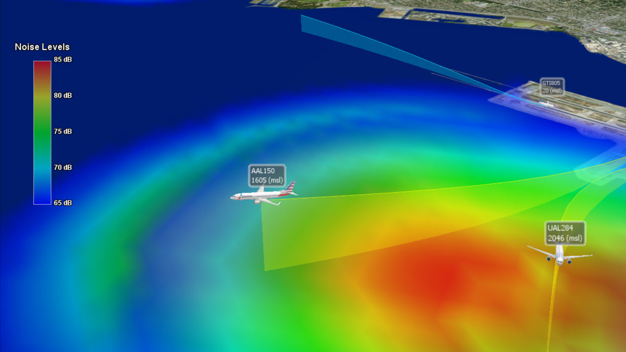
To communicate the complex volume of information succinctly to more than 200 attendees, we used Volans®, our innovative, proprietary 3D airspace visualization software tool, and a customized Zoom webinar platform to host the public workshops. This included facilitating panel discussions, which enabled FAA’s experts to answer more than 100 live questions during the public workshops. The events also were streamed to FAA’s social media channels to maximize reach and participation. The communication advantage of using our award-winning Volans tool for air traffic visualization and communications software proved enormous during the workshops.
Volans supports public airspace interests
Volans is used by airports and air service organizations for operations monitoring, procedure validation and environmental analysis, high-quality image and video content for community outreach, obstruction analysis of new runway development, and automation of the use of the FAA’s Aviation Environmental Design Tool.
Tetra Tech applied decades of experience to design and build Volans, creating a tool that solves issues facing noise offices, streamlines data collection and outputs, and conveys complex messages succinctly. It is a very useful tool for immediate visual communication and visual concept of operations.
Our 3D visualization services encompass innovative approaches to graphically display the airspace and provide fast playback of operations, such as with the Los Angeles World Airports’ LAX Noise Portal.
NAV CANADA, Canada’s air navigation service provider, recently renewed its Volans license, and we will provide them with community outreach services like those for the FAA. As new flight procedures are designed and implemented at busy airports, Volans will be used to visualize and communicate new flight paths and projected changes in noise exposure and greenhouse gas emissions. Volans also will be used to create animations, graphics, and other visuals for community outreach events and materials.